
Undoubtedly, digital and mobile technologies are penetrating in all spheres of our lives. The increasing ubiquity and pervasiveness are also transforming our physical living space into a meditated and hybrid place.
The Project C3Places developed a framework for better understanding how digital tools can support the co-creation processes.
The types of ICT tools and their supporting devices were systemised in main category groups describing where the tool is installed in relation to the public space and how an ICT tool interacts with the user.
How ICT provision can improve aspects of spatial use and quality?
Authors: Ina Šuklje Erjavec
To better understand and present the complexity of the relationship between users’ needs for space use and quality and the necessary attributes and ways of using ICT tools to improve various aspects of space quality, we have prepared an overview table that includes and shortly describes key spatial quality aspects of the outdoor setting, list of some user needs related to both spatial and ICT use, ICT attributes relevant to fulfil those needs, some possibilities and types of ICT implementation, and suggestions of related added values to listed spatial quality aspects.
Legend:
- AR = Augmented Reality
- LT = Location Technology
- W = Wi-Fi
- VT = Vision Technology
- DM+ = Data Management plus more
| SPATIAL QUALITY ASPECTS | USER NEEDS | DIGITAL TOOLS /ICT | DIGITAL TOOLS /ICT | ADDED VALUES |
| Attributes | Type of implementation | |||
| (Public) Accessibility | Physical accessibility orientation, navigation, access for all (inclusiveness) Accessibility to technology – skills/use, affordability, equality (inclusiveness) | Easy to use (intuitive) devices, (no need to be ICT-literate) Path quality – access for all Online information before visiting place – available for all needs | Wayfinding apps – “filtering’ based on user profile and requirements Overlaying of additional information within App for specific purposes (augmented reality); In-situ devices LT, AR | • Enhancing access for all (facilitating it) • Responding more specifically to user requirements, • Possibility for user feedback to enrich data |
| Security | To feel safe in the space, not to be controlled or observed; to retain: – physical safety – emotional/ – psychological safety Internet security – not to be hacked | Physical and virtual privacy, confidence, alert to danger, feedback, security check | ICT tools and apps for: – Lighting – Sound and light interactivity – Suitable structure of place, good visibility, – Validated networks Monitoring cameras AR, LT, VT, W, DM | • Social networking • User’s involvement • New users • Higher usability • New ways of lighting • Flexibility • Activation system |
| Legibility | To understand the place/move easily | Readability | Planning – Layout and way-marking AR, LT, VT, W, DM | Better orientation flow of movement |
| Clear Identity of place | Unique features | Artworks, landscaping, facilities | Recognition, significance | |
| Sociability | Participation and inclusion Interaction | Gathering / social settings Interactive settings Play features | Clear space/ICT demarcation /time- independent but spatially localised social interaction AR, W, DM, LT | Well-being and social cohesion, ownership/care sense of belonging, e-agora |
| Adaptability | Adapt to special needs Co-create – temporarily change Capacity for individual change | Future-proof design Flexibility Ephemerality | Apps, Wi-Fi Sensors, Screens and other in-situ devices and settings (Regular maintenance and updating needed) VT, DM, W | Co-creation, citizen input, experimentation of solutions, possibly temporary |
| Functionality | Accessibility Comfort | Welcoming spaces, clear pathways | Social design and facility provision DM, LT | System trust |
| Connectability | Between spaces (permeability), people and information | Secure and high-bandwidth provision | Maintaining networks, facilitation W, DM | Social cohesion, communication |
| Variety | Attractors Opportunity of choice | Gaming, social, information layers | Embedded games and play, socially hybrid spaces – e.g. chess/coffee AR, LT, VT, W, DM | • Enjoyment • Play • New uses • Innovation |
| (Social) resilience in the face of emergency | Obtain and give effective and reliable information; Knowledge as to where to go; Access to amenities Organisational support for groups | Quick responsiveness Spatial adaptability to user needs ICT-functioning support Accessibility (to both space and technology) | Energy independence or passive energy generation Monitoring devices e.g. air/water quality, waste… W, DM, VT, LT | • Timely information provision and exchange • A direct communication channel e.g. via social media • Monitoring available resources |
| Environmental / ecological sustainability | Optimal microclimate Water retention Biodiversity Pollution and natural disaster mitigation | Real-time monitoring via sensors Visualising the information in situ | Sensors Screens Apps DM, VT, LT, in situ sensors | • Raising awareness and knowledge • Support policymaking and management |
| Health (physical and mental) and wellbeing | Outdoor physical activity Mental restoration (connection with nature) Knowledge about optimal environmental conditions to carry out physical activity | Challenging and attractive environment for physical activities; Virtual environment to enhance wellbeing; Real-time information; Health-related statistics | Innovative elements that invite one to perform physical activities Screens, Apps Games AR, VT, LT, DM | • Raising awareness, knowledge, promotion of a healthy lifestyle; • Attract new people outdoors; Incentivise activity of visitors; • Offer new experiences |
References:
- Šuklje Erjavec, I. & Žlender, V. (2020). Categorization of digital tools for co-creation of public open spaces. Key aspects and possibilities. Planning Practice and Research (165-183). In Smaniotto Costa, C., Mačiulienė, M., Menezes, M. & Goličnik Marušić, B. (Eds.). Co-Creation of Public Open Places. Practice – Reflection – Learning. C3Places Project. Lisbon: Lusófona University Press. https://doi.org/10.24140/2020-sct-vol.4-2.1.
- Šuklje Erjavec, Ina, and Ruchinskaya, Tatiana (2019). A Spotlight of Co-Creation and Inclusiveness of Public Open Spaces. In CyberParks – The Interface Between People, Places and Technology, edited by Smaniotto Costa C. et al. Lecture Notes in Computer Science, vol 11380. Springer, Cham.
- CyberParks Project. Pool of Examples (n.d.). Retrieved June 7, 2019. Available at http://cyberparks-project.eu/examples
Evaluation of digital tools for co-creation of public open space
Authors: Ina Šuklje Erjavec, Vita Žlender
In relation to the Digital Co-Creation Index – a tool to assess, measure and compare digital co-creation initiatives, a conceptual framework was elaborated to convey the penetration of ICT into public spaces. The criteria are structured according to three aspects: spatial quality aspects, user-related aspects, and technological aspects (Figure 1).
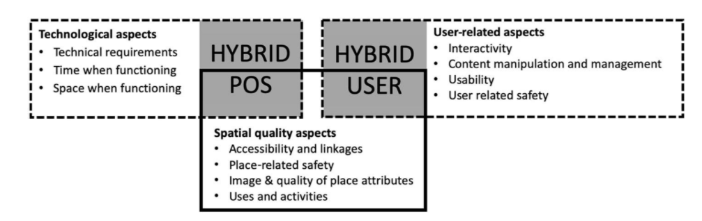
SPATIAL QUALITY ASPECTS
The approach to evaluating these aspects is grounded on basic principles of researching, understanding and designing public spaces developed by theorists and practitioners such as W.H. Whyte, J. Gehl, S. Carr and others. Specifically, the criteria, indicators and tools from the Project for Public Spaces “The Place Diagram” (Project for Public Spaces, 2009) and Jan Gehl’s “12 Urban Quality Criteria” (2017) were examined more profoundly.
SPATIAL QUALITY ASPECTS
The approach to evaluating these aspects is grounded on basic principles of researching, understanding and designing public spaces developed by theorists and practitioners such as W.H. Whyte, J. Gehl, S. Carr and others. Specifically, the criteria, indicators and tools from the Project for Public Spaces “The Place Diagram” (Project for Public Spaces, 2009) and Jan Gehl’s “12 Urban Quality Criteria” (2017) were examined more profoundly. In addition, we took into consideration the outcomes of the CyberParks Project and evaluated the performance of the C3Places POS Quality Index (C3Places, 2019) for the Living Labs assessment that we adapted to the current context of POS, with its digital transformation in mind. The main spatial quality aspects which include additional dimensions relevant for ICT penetration into POS, are defined as:
- Accessibility and linkages – Legibility, Navigation, Convenience for movement, Interlinking, Level of physical, social and digital accessibility.
- Place-related safety – Vandalism, Traffic, Injuries, Environmental safety (monitoring).
- Image & Quality of place attributes – Attractiveness, Personalisation and individual creation possibilities, Adaptability, Monitoring, Environmental quality and Ecological sustainability.
- Uses and activities – Communication and education possibilities, Access to information, Sociability, Research possibilities, Playfulness, Variety, Responsiveness, Service provision, Health and wellbeing.
USER-RELATED ASPECTS
To define criteria for these aspects, our guiding question was: Which characteristics of ICT are needed to satisfy use and successful co-creation experiences? As basis for development of criteria the Social Responsiveness Index and the Digital Inclusiveness Index were used, plus a sub-indices of Digital Co-Creation Index (C3Places, 2019) and literature review of existing classifications and criteria of ICT features to enable satisfactory user experience. We considered criteria for methods and approaches selection from “Participedia” (n.d.) and the work of Kaplan & Haenlein (2014), who focused on collaborative projects, such as one on ICT tools, grouping them along two dimensions: type of knowledge that is created within a collaborative project, and mutual independence of individual contributions. We define user related aspects as:
- Interactivity – User’s engagement along with the device/ media/ application used, its type of interaction, degree of interaction and type of experience
- Content manipulation and management – How is it provided and what is user supply?
- Usability – Ease of use, respect for privacy, saving work for future use, customization potential, possibility of choice
- User-related safety – security and privacy assurance technology (protection of personal data, anonymity of ideas, etc.) and social resilience
TECHNOLOGICAL ASPECTS
The guiding question for the technological aspects was: How can digital technology support quality of place and the way the place is used and developed? The main issues to define are:
- Technical requirements regarding software, hardware and network communication, and their installation: is there a need for the internet, are any specific operational systems required, i.e. electricity, speakers, etc.?
- From the time-related point of view: is the ICT tool functioning permanently or temporarily, continuously or intermittently?
- From the point of view of functioning place: is the ICT tool static, located in the POS, portable, to be used in POS, or remotely accessible to be used for distant POS-related activities?
On this basis, we have systemised types of ICT tools and their supporting devices in three main categories which describe where the tool is installed in relation to the open space and how an ICT tool interacts with the user. The subtypes of tools are defined according to POS, user-related functions and specific characteristics. Thus, the developed framework for classifying digital tools for co-creation is addressed in the next section.
References:
- Šuklje Erjavec, I. & Žlender, V. (2020). Categorization of digital tools for co-creation of public open spaces. Key aspects and possibilities. Planning Practice and Research (165-183). In Smaniotto Costa, C., Mačiulienė, M., Menezes, M. & Goličnik Marušić, B. (Eds.). Co-Creation of Public Open Places. Practice – Reflection – Learning. C3Places Project. Lisbon: Lusófona University Press. https://doi.org/10.24140/2020-sct-vol.4-2.1.
- C3Places. (2019). Methodological Framework for LIVING LABS in European Cities. Available athttps://c3places.eu/outcomes.
- Gehl, J. (2017). Twelve Urban Quality Criteria. Available at https://gehlinstitute.org/wp-content/uploads/2017/08/TWELVE-QUALITY-CRITERIA.pdf
- Kaplan, A., & Haenlein, M. (2014). Collaborative projects (social media application): About Wikipedia, the free encyclopedia. Business Horizons, 57(5), 617–626. Available at https://doi.org/10.1016/j.bushor.2014.05.004.
- Participedia. (n.d.). Retrieved 27 March 2019.
- PPS – Project for Public Spaces. (2009). What Makes a Successful Place? Retrieved 10 June 2019. Available at https://www.pps.org/article/grplacefeat.
Possible benefits of using ICT tools in co-creation process
Authors: Ina Šuklje Erjavec, Vita Žlender
To effectively use all the ICT potential it is important to understand co-creation in its broader sense: as a process that includes all stages of POS development and addresses all types of related collaboration activities, such as involving end users (citizens) and other relevant stakeholders, sharing information and local knowledge, collaborating on data gathering, expressing opinions, needs, wishes and values, defining priorities, visions and aims, working on decision making as well as placemaking with different participatory planning and co-design activities and comanagement (Šuklje Erjavec, 2017; Šuklje Erjavec & Ruchinskaya, 2019).
As further next step towards better understanding the possibilities for co-creation, we developed the following structure of the possible use of different ICT tools. It explains the type of function and way of integration in the process of planning and design, place making, place management and community engagement.
FOR EXPERTISE WORK – technology for supporting spatial development processes
>in the process of spatial planning and design, digital tools could be used to better:
- Understand, analyse and evaluate spatial and social state of the art faster, more deeply and comprehensively
- Assess and evaluate proposals more transparently
- Develop more transparent solutions, scenarios and models
- Present solutions more understandably and efficiently for non-experts (hardware and software)
- Perform sharing, co-production, co-creating, co-designing between experts and with stakeholders
FOR PLACE FUNCTIONING – technology in place & technology supporting the use of place
>in the process of place making, digital tools could increase:
- Responsiveness and adaptability of place
- Communication about place and within place
- Orientation and access to information
- Attractiveness, usability and playfulness of place
- Identity and recognizability of place
- Personalization and individual creation possibilities
- Education possibilities
- Research possibilities, etc.
>in the process of place management, digital tools could increase
- Monitoring – environmental and spatial quality
- Maintenance feedback (sensors, mobile apps, platform)
- Work coordination
- Traffic management
- Cultural content management
- Technical management
- Maintenance management
- Information management, etc.
FOR COMMUNITY ENGAGEMENT – technology for supporting community engagement
>to raise awareness and increase involvement of the community, digital tools could increase the effectiveness of:
- Information collection, sharing and management
- Social communication, interactivity and networking management
- Public involvement and participation
- Co-creation process management
- Construction of community capacity and common issues and goals
Reference:
Smart Co-design. An interdisciplinary approach to urban planning via Augmented/Virtual Reality and process mining
Authors: Barbara Piga, Marco Boffi, Nicola Rainisio, Gabriele Stancato, Paolo Ceravolo, Gabriel Marques Tavares
In the field of urban planning and design, citizens’ involvement has undergone a constant evolution. This has taken place in quantitative terms, with an increasing number of citizens involved in each urban transformation, together with a greater number of initiatives for collaborative approaches (Davies et al., 2012). Such evolution is also qualitative, as more attention is nowadays devoted to disadvantaged social minorities and citizens are more often considered as partners rather than passive observers (Bisschops & Beunen, 2019). In this context, the opportunities offered by ICT solutions have represented a natural field of expansion for these practices. This process has been further strengthened by the rapid and widespread diffusion of mobile devices, which allow building networks interconnecting different actors, at the same time and in different places, among them and with the city. Moreover, such interaction between urban planning and ICT has produced several innovations in terms of services offered to the citizens (Dunn, 2007; Piga et al., 2021).
Yet, the role of the social sciences has so far been partial in those initiatives, despite the proximity of some research issues. In particular, environmental and community psychology developed several theoretical concepts and measurement tools relevant for this field. Thanks to their implementation, the relationships of individuals within a community and with the physical environment in which they live can be effectively described. This union between the physical and intangible components of the places we live has rarely been effectively integrated into applied tools (Boffi & Rainisio, 2017). At the intersection of these different perspectives on experiential urban planning (Piga, 2017) lies the starting point of the collaboration between the Università degli Studi di Milano and the Politecnico di Milano.
It was further developed thanks to the “AR4CUP: Augmented Reality for Collaborative Urban Planning” projects (2019 and 2020), part of the H2020 EIT Digital (Digital Cities) funding program whose Italian partnership was led by the Politecnico di Milano. The objective of the project is to support the design of urban spaces, through an app (AR4CUP) that makes people’s urban experiences evident and quantifiable using synchronous behavioral data (Seeber, 2014).
In a nutshell, this smart co-design approach fosters the inclusion of the urban communities perspectives in the design process. Mixed Reality is exploited to combine real and virtual environments (Carmignani et al., 2011). The result is a combination of information coming directly from the real environment with information coming from design artifacts: data are collected recording the user response to this mixed reality in real-time. Indeed, the app has different functions that enable its application throughout an entire co-design process:
- it shows, on-site through Augmented Reality and off-site through Virtual Reality, urban and architectural proposals geolocated in real dimensions before their actual implementation; it also allows to explore the current condition of the neighborhood;
- it collects data from citizens’ reactions to proposed urban transformations or to the current environment, combining emotional, cognitive and behavioral factors through scientifically validated instruments;
- it develops automatic data analytics to study the user’s behavior, to verify its conformance with the design goals and to identify space utilization not explicitly considered by the design plans;
- it represents the outcomes in various forms, including charts and maps of the places as they are subjectively perceived.
The app and its outcomes are conceived as a tool for facilitating the interaction among stakeholders of urban transformations (e.g. Architectural Firms, Real Estate Developers), institutions (e.g. Local Public Administrators, Regional or National authorities) and citizens (e.g. dwellers, commuters, tourists). It eases the creation of a shared representation of places, combining together objective environmental features and subjectively perceived values. Such common ground is crucial for informing designers and decision-makers about citizens’ needs, which might impact on the project development. In addition, it is a way to effectively inform citizens and actively engage them in the urban transformation from the very beginning of the process.
References
- Bisschops, S., & Beunen, R. (2019). A new role for citizens’ initiatives: The difficulties in co-creating institutional change in urban planning. Journal of Environmental Planning and Management, 62(1), 72–87.
- Boffi, M., & Rainisio, N. (2017). To Be There, Or Not To Be. Designing Subjective Urban Experiences. In Urban Design and Representation (pp. 37-53). Springer, Cham.
- Carmigniani, J., Furht, B., Anisetti, M., Ceravolo, P., Damiani, E., & Ivkovic, M. (2011). Augmented reality technologies, systems and applications. Multimedia tools and applications, 51(1), 341-377.
- Davies, S. R., Selin, C., Gano, G., & Pereira, Â. G. (2012). Citizen engagement and urban change: Three case studies of material deliberation. Cities, 29(6), 351–357.
- Dunn, C. E. (2007). Participatory GIS — a people’s GIS? Progress in Human Geography, 31(5), 616–637.
- Piga, B. E. (2017). Experiential simulation for urban design: From design thinking to final presentation. In Urban Design and Representation (pp. 23-36). Springer, Cham.
- Van Der Aalst, W., Adriansyah, A., De Medeiros, A. K. A., Arcieri, F., Baier, T., Blickle, T., … & Burattin, A. (2011, August). Process mining manifesto. In International Conference on Business Process Management (pp. 169-194). Springer, Berlin, Heidelberg.
Exploring teenagers’ spatial practices and needs in light of new communication technologies
Author: Carlos Smaniotto Costa, Joana Batista, Inês Almeida, Marluci Menezes
There is an increasing awareness and advocacy claim for engaging the society in the production of public open spaces. This contribution seeks to increase knowledge on the relationship between spaces and the social practices of teenagers, towards a more inclusive and interactive process of public space co-creation. It is based on two European Projects: CyberParks and C3Places, and explores teenagers’ spatial practice and needs, and how to engage them in the process of co-creating more sensitive public spaces, while exploring the challenges and opportunities ICT open. This paper, the results of a case study taking place in Lisbon and the analysis of questionnaires and interviews are discussed.
Smaniotto Costa, C., Solipa, J., Almeida, I., & Menezes, M. (2020). Exploring teenagers’ spatial practices and needs in light of new communication technologies. Cities, vol. 98. DOI: 10.1016/j.cities.2019.102574.
An example of digitally shared infrastructure creating a partecipatory community in an urban open spaces
Author: R. Pizzi
An open project of the Department of Computer Science of the University of Milan, PEOPLE HAVE THE POWER , in collaboration with the Polytechnic University of Milan (Department of Architecture, Construction Engineering and Built Environment) has proposed a geolocalized app that allows to find in the vicinity of your vehicle private buildings available to lend an electric outlet for charging electric vehicles, especially in yards, garages or parking spots.
As shown in the dedicated platform, the app allows individuals, companies or commercial activities to register, describe their service, arrange payment via PayPal or credit card, or promote their charging spots with scores collection and exchange, discounts etc.
Users can use the recharge service while leaving the vehicle for commissions or for leisure, or during a holiday trip or when stopping for the night.
The project was developed and a charging point was realized in the “Study City” Campus and has become a point of interest of the Social Campus platform (Figures 1, 2, 3, 4)
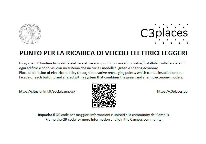
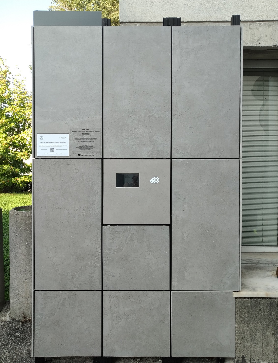
Figure 1: Social Campus: the QR code tag of the Smart charging point for soft electric vehicles.
Figure 2: The Smart charging point, inserted in the facade of the building.
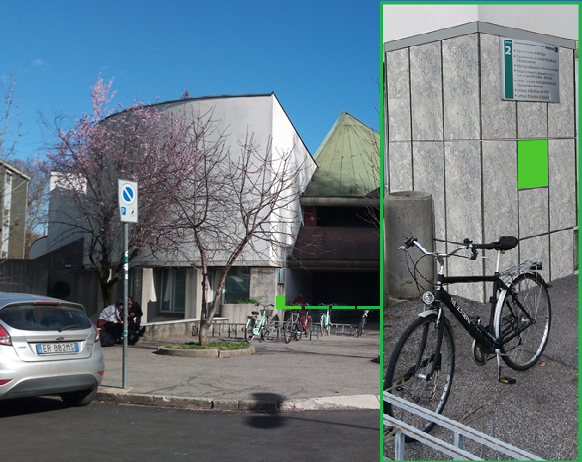
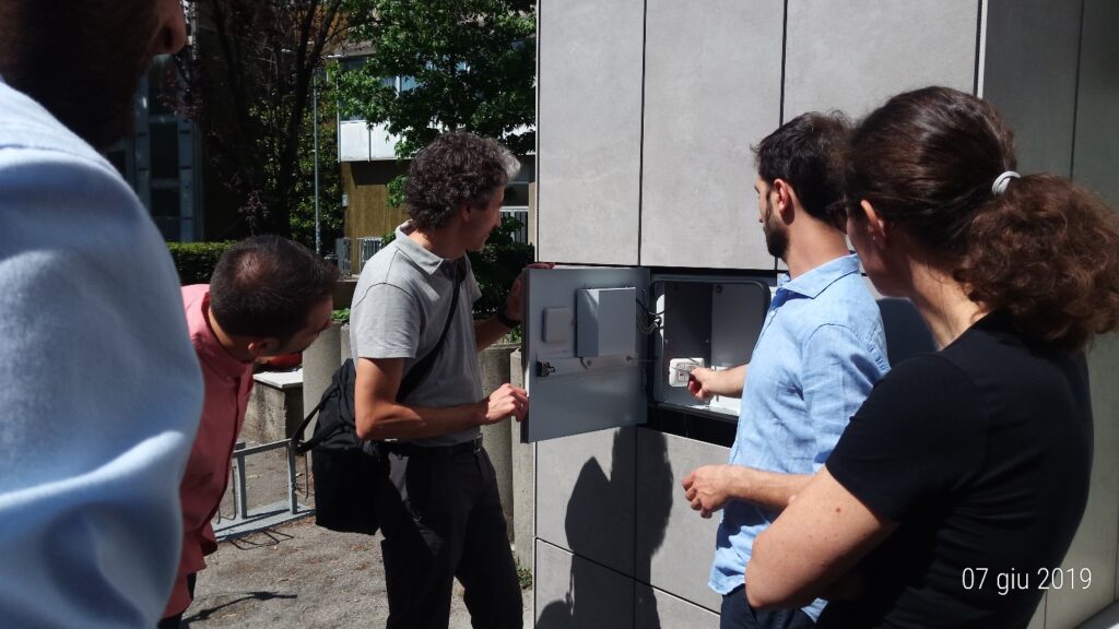
Figure 3: Smart charging point position.
Figure 4: Smart charging point close-up view.
Social Campus
Author: R. Pizzi
The platform was created by the Department of Computer Science of the dell’Università degli Studi di Milano of the as part of the C3Places European Project, which aims to develop strategies and tools to increase the quality of open public spaces through the information and communication technologies. This platform aims to create a community of students, teachers and citizens who attend the Città Studi Campus and its open spaces.
On this web site you can ask, receive and yield information on the various places of interest scattered around the area simply by registering.
Entering the dedicated pages it will be possible to interact with the registered members that share the same interests. In the groups section you will be able to communicate with the registered members (Figure 1). The group page can also be reached by scanning the QR code on the plate affixed in proximity to the point of interest (Figures 2 and 3).
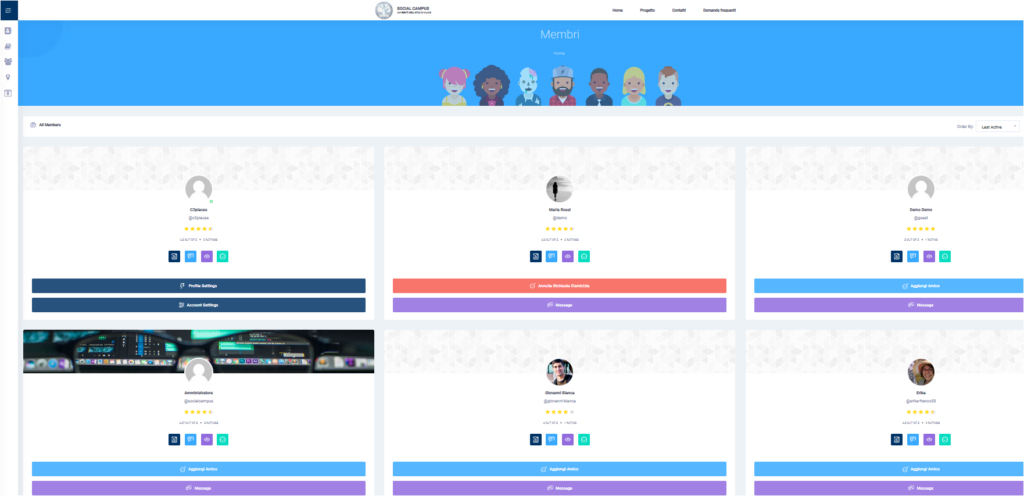
Figure 1: Social Campus view of the members page and of a chat between members.
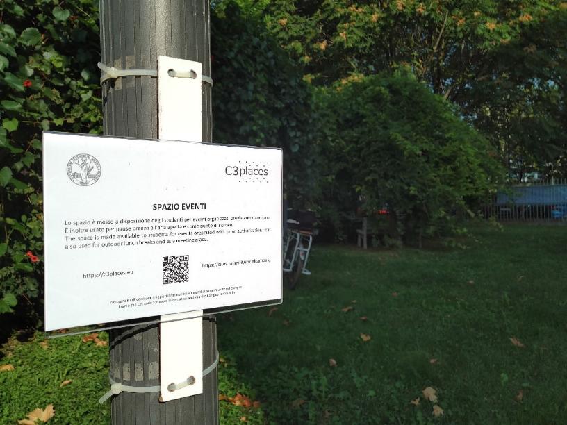
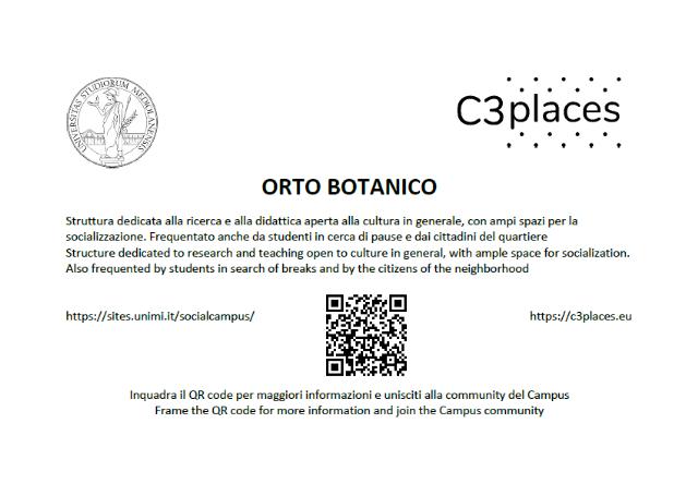
Figure 3: Social Campus: an example of QR code tag.
The University of Milan contribution to the C3Places Project
Author: R. Pizzi
The presentation at the link describes the idea developed by the UNIMI team: a vibrant new way to create a community that could really communicate and help and grow not only virtually but also in presence *by means* of technology.
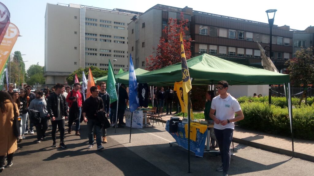
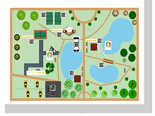
Urban open space can easily become center of shared services and cultural events and opportunities and knowledge (Figure 1).
The availability of public hot spots in public places can be seen as a social service, where digital infrastructures may become a way for the supply of public services, ideas, creativity, opportunities for co-creation and collective cultural and social interchange, promoting sustainability, responsibility and knowledge of nature, the city and citizenship in its cultural diversity.
University of Milan main task in C3Places project was the development of a co-creation platform providing a scientifically validated framework for citizens’ interaction in and with public spaces, leveraging on their diversity potential of co-creation.
A social network built around points of interest of public open spaces, where people can exchange usefule information, moods, requests, ideas.
A complete example has been developed and experiment, yield the novel digital tool to students of the Campus, open also to the citizens living in the area.
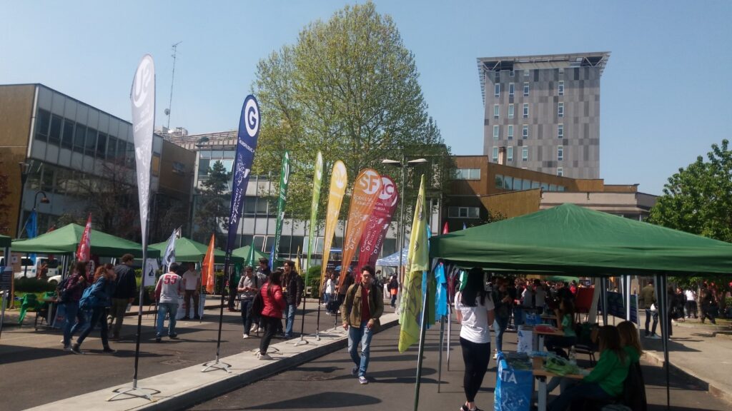
Figure 1: View of the “Città Studi” area.
Participatory co-creation and urban sustainability: the role of cooperation in the ICT era
Authors: R. Pizzi, A. Merletti De Palo
In the last decade Information and Communication Technologies (ICT) have become an important tool for socialization. However, living public open spaces firsthand remains fundamental for the development of the cultural identity of a community. ICT allows to develop strategies and tools to increase the quality of public open spaces, positively influencing the co-participatory creation and the effects of social cohesion (Figure 1).
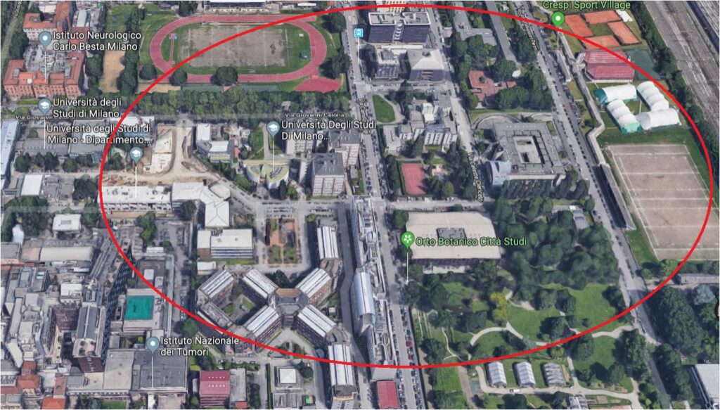
Figure 1: The university area “Città Studi” where the Social Campus points of interest are located.
As part of a European research project called C3Places, we intend to generate knowledge and knowhow for a co-creation approach to be used to combine the use of ICT and the studies on cooperation with the essential functions and new potential of the public open spaces (Figures 2 and 3).
We explored the new dynamics of the open spaces as a value-added service for the community, paying attention to the parties interested, to the local context and to the different social groups.
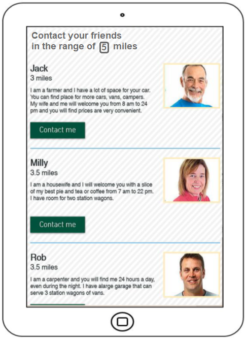
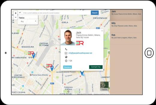
Figure 2: App interface: services and contacts of the private charging points.
Figure 3: The private charging points are geolocalized.
Co-Creazione partecipativa e Sostenibilità Urbana: il Ruolo della Cooperazione nell’Era dell’ICT 2018 / R. Pizzi, A. Merletti De Palo – In: Città Sostenibili / [a cura di] C. Fiamingo, V. Bini, A. Dal Borgo. – Prima edizione. – Broni : Altravista, 2018 Dec. – ISBN 9788899688400.
Digitally Supported Co-creation within Public Open Space Development Process. Experiences from the C3Places Project and Potential for Future Urban Practice
Authors: Vita Žlender , Ina Šuklje Erjavec, Barbara Goličnik Marušić
This research aimed to explore information and communication technologies (ICT) types to support co-creation activities in public open spaces (POS) at different stages of the co-creation process.
We conducted state-of-the-art research on the methods, best practices, obstacles and potential of ICT tools and co-creation activities to ease the interaction between stakeholders engaged in the process.
Based on those findings, we proposed an ICT tools selection framework. Four living labs were analysed to better understand the practical side of digitally aided co-creation.
We conclude by exposing challenges and suggest ways to move forward toward genuinely digitally supported co-creation of the POS.
Vita Žlender , Ina Šuklje Erjavec & Barbara Goličnik Marušić (2020): Digitally Supported Co-creation within Public Open Space Development Process: Experiences from the C3Places Project and Potential for Future Urban Practice, Planning Practice & Research, DOI: 10.1080/02697459.2020.1829286
Interactive soundscape augmentation of an urban park in a real and virtual setting
Authors: Timothy Van Renterghem, Kang Sun, Karlo Filipan, Kris Vanhecke, Toon De Pessemier, Bert De Consel, Wout Joseph, Dick Botteldooren
Inappropriate soundscapes are able to strongly deteriorate the user experience in parks. A possible remediation is adding positively perceived sounds.
The case of an urban park, fully surrounded by road traffic noise sources, was studied to explore the potential of adding natural sounds in an interactive way. A preliminary test was conducted in the lab with Virtual Reality (VR) glasses and headphones.
The audio-visual representation of the real environment was obtained by combining binaural recordings with first-order ambisonics and 360-degree video camera footage.
The users were allowed to mix in eight types of natural sounds until their personal optimized soundscape was composed. This was done in a very similar setup as in the (real) park. The loudspeaker augmenting the sound environment in the park was steered with a smartphone application.
This app ensured the user’s presence near the loudspeaker and allowed to gather more detailed assessments of the perceived sound environment through questionnaires. This combination of experiments allowed checking the validity of VR that is becoming increasingly popular in audio-visual interaction studies. In addition, the most preferred natural sounds and the way they influenced environmental noise perception were analyzed.
Van Renterghem, T., Sun, K., Filipan, K., Vanhecke, K., De Pessemier, T., De Coensel, B., … Botteldooren, D. (2019). Interactive soundscape augmentation of an urban park in a real and virtual setting. In M. Ochmann, M. Vorländer, & J. Fels (Eds.), Proceedings of the 23rd International Congress on Acoustics : integrating 4th EAA Euroregio 2019 : 9-13 September 2019 in Aachen, Germany (pp. 899–903). Aachen, Germany: Deutsche Gesellschaft für Akustik.
Types of ICT tools
Authors: Ina Šuklje Erjavec, Vita Žlender
The development of digital technologies opened new opportunities for different collaborative processes, many new possibilities to engage and activate people, and for new ways of interacting with the environment. On the basis, of the possible use of different ICT tools in the relation to the type of function and way of integration in the process of planning and design, place making, place management and community engagement. We have systemised types of ICT tools and their supporting devices according to location of the tool in the relation to the open space and the way of its interaction with the user. In that was we defined three main categories:
- Place-located ICT tools
- Portable ICT tools
- Remotely accessible ICT tools
Each category is also structured into the subtypes of tools, which are defined according to POS, user-related functions and specific characteristics. The subtypes of tools are defined according to the POS and user-related functions and specific characteristics.
Place-located ICT tools
These tools are located ‘in place’ and installed as a part of physical features of POS. Such digital tools add new functions into existing place or are part of the design of the new one, combining digital and physical layers into a new hybrid use. The overview of place located ICT tools is presented in the following table.
| Type | Subtype |
| Individual digital elements as new types of equipment in POS | Digital public displays Public interactive displays Multimedia interactive elements Multifunctional tech totems Interactive and responsive sound installations Responsive lighting elements Multimedia pavilions Interactive POS elements: a combination of different digital elements (e.g. screens + speakers + lighting) as artistic installations per se or frames for them, responsive sculptures and fountains, play equipment, etc. Individual elements for energy provision, as electric vehicle charging stations, solar energy stations, etc. |
| Digital part(s) of POS equipment or parts of surrounding buildings and equipment | Digital elements upgrading or supporting the functioning of urban elements (these are incorporated into traditional types of POS furniture like bench, table, fence, light, playing or sport equipment, etc.) Digital additions for upgrading the functioning, maintenance or experience of the area like WI-FI hotspot, speakers, QR codes, sensors, beacons, universal intelligent nodes Elements for energy provision to support use of portable ICT devices that are incorporated into traditional types of POS furniture, playing or sports equipment, etc.) in a form of plugs, solar panels, etc. Media facades as part of other built structures, e.g. facades, walls, etc. Projection mapping (Digital projectors) Digital projectors as part of other built structures, e.g. facades, grounds, walls, etc. SAR (spatial augmented reality) systems: – Shader lamps (projector-based augmentation) – Mobile projectors – Virtual tables – Smart projectors (projection mapping), etc. |
| Responsive materials | Adaptive pavements (adapting to the weather, accessibility needs, etc.) Responsive verticals (changing by touch, sound, etc.) Measuring materials (for monitoring the use, conditions, etc.) Self-cleaning, self-repairing and materials |
Portable ICT tools
These tools bring a user to the public open space and establish a relationship with space, other users and/or other premises. Their main purpose for POS development and co-creation is to develop new forms of uses and activities in POS by extending human abilities, i.e. adding a digital sense to five basic human senses and to support a direct feedback of users for better POS development and management. Their structure is presented in the following table.
| Type | Subtype |
| Smart devices | Smartphones and tablets Smart glasses (e.g. Google Glasses) Smart grid Smart watches (e.g. iWatch), etc. |
| Place related mobile APPS | Directly supporting learning about place and its natural and manmade characteristics, adding to the experience of place, support moving through it, activity and movement tracking) Collect and share data on environmental conditions, evaluate conditions, etc. Directly support place evaluation and feedback VR and AR apps for opinion and proposal development and sharing, etc. Other apps are discussed within web platforms and apps (Table 3) |
| GPS -positioning devices | Individual or as part of other smart devices |
| Other personal VR and AR devices | Head-mounted displays (e.g. headsets, eyeglasses, contact lenses) Multi-projected environments Combination with physical environments or props (e.g. 3D mouse, the wired glove, motion controllers, optical tracking sensors) |
| Cameras, recorders | Many different options |
| E-textiles – aesthetic and performance enhancing | Smart garments, smart clothing, smart textiles, or smart fabrics providing the added values to the wearer, enabling the interaction with the environment and responsiveness to the personal activities and condition Wearable computing with microcontrollers, sensors and actuators |
| Digital health and fitness tools | Devices and apps to encourage healthy habits, fitness and other physical activity tracking, health measurements, Internet connected fitness systems, Environment quality sensors and alarm systems |
Remotely accessible ICT tools
This group encompasses, on the one side, a broad variety of ICT tools such as laptops, PCs, screens, mobile phones and other hardware, and on the other, web platforms and apps used for digitally networked interactions such as distant society engagement, public consultation, information and opinion collection, exchange and sharing, voting, etc. Their general advantage is that they can at one time reach a much larger number of people who can also choose their own time of use.
In the structure we focus on aspects that are very important to support different co-creation activities for POS development, such as preparation, discovering, debating, deciding, designing, implementation, maintenance, use, and monitoring of public open spaces. The following table provides a general overview on how different components and tools enable and support different dimensions of remote public involvement.
| Type of components / tools | Examples |
| Social networking platforms and sites | Pinterest, Facebook, Instagram |
| Static web sites | Professional portfolios, digital curriculums |
| Blogs and microblogs | WordPress, Joomla, Drupal, Twitter |
| Tools for social bookmarking, tagging | Tools for social bookmarking, tagging |
| Online storage (cloud storage, file synchronisation, personal cloud) | Dropbox, GoogleDrive, iCloud |
| Social network aggregation | Hoot Suite, FriendFeed |
| Encyclopaedia | Wikipedia |
| Survey | Google Forms, SurveyHero, Typeform, SurveyMonky, InvolveMe |
| Content communities – Online databases of multimedia content, that allow users to share online multimedia materials by photo, video, podcasts, presentations, etc. | Flickr, SmugMug, Picasa, GigaPan Youtube, Vimeo iTunes SlideShare, VoiceThread |
| Internet forum / Message board Textboards and Imageboards | Quora, SkyscrapperCity |
| Chat rooms in the form of Web conferencing, Video conferencing, etc. Instant messaging | Facebook Messenger, Gmail messenger, WhatsApp |
| Electronic mailing list, news group | Mailing lists of different organisations, companies, institutions, etc. |
| Online dictionaries | Urban Dictionary |
| WEB GIS – Analytical – Animated and real-time – Collaborative (e.g. PPGIS) – Online atlases, etc. | Open Street Map, Google maps, Apple maps, and many different projects specific and city specific data collection platforms |
| Web-based simulation platforms and apps for discrete events, continuous events, etc. | Digital participatory platforms: Mobility Testbed, Commonplace, coUrbanize, TransformCity, etc. |
| Construction and management simulation games, e.g. city building games | Lincity, SimCity, etc. |
| Augmented reality apps | Pokemon GO, ScentExplore |
| Virtual social worlds | Second life |
Reference:
The C3Places mobile application
Authors: Inês Almeida, Joana Batista, Carlos Smaniotto Costa, Marluci Menezes
Developing and testing of a mobile application to support research activities is one of the goals of the C3Places Project. The C3Places application is designed to enable researchers to address questions related to the use of public spaces via digital technology. A relevant aspect of the digital and mobile technologies lies in their possibility to enhance communication with prospective users, hence enabling possibilities for creative participation in placemaking and co-creation.
The C3Places application consists of two main components: a web service (web platform) and the smartphone application (app) and is enabled to be used anywhere in the world.It allows researchers to collect evidence base and demonstrate the social values of public spaces – backed by users’ opinion and views. Also, by providing evidence and demonstrating that public space is having a positive societal impact can increase the enthusiasm for more inclusive and responsive public spaces.
By collecting such data, the C3Places App contributes to better explore and more precisely research on public space practices, as well integrate the use and point of view of several users on different spaces. Another interesting feature lies in the possibility to collect the weather conditions automatically, therefore researchers can also reflect on how weather conditions affect (or not) the usage of public open spaces.
Finally, considering that it is up to the researcher to create the questions or the photo questionnaire, the possibilities are infinite and can be addressed directly to each research topic that is being carried out. So, the C3Places app allows scholars and researchers to make more specific or broader public open space research and, since it runs in Android operative system, the range is quite extensive. The use of the C3Places App is free and can be requested at c3places.coordination@ulusofona.pt.
The manual for preparing a research subject with the help of the C3Places App can be downloaded here.
ICT-Based Participatory Co-Creation of Urban Sustainability
Author: Rita Pizzi
In recent times Information and communication technologies (ICT) have become an important tool for socialization. More and more people build and maintain relationships through various social media and increasingly this influences the way they organize their daily lives and how they use the city and its spaces. However, the quality of public open spaces remains fundamental for the development of the cultural identity of a community, as they are important gathering points in the urban fabric and offer occasion for interactions and collaborations between generations and different ethnic diversities. People of all ages still need contact with nature and with other people, in order to develop different life skills, values, attitudes to health, satisfaction with their lives and responsibility towards the environment. ICTs allow the development of strategies and tools to increase the quality of public open spaces, positively influencing participatory co-creation and the effects of social cohesion. New ways of cooperative co-creation must be considered, in particular by using ICT to facilitate community interaction and engagement for the integration of diversity, and identifying social needs in open public spaces, aiming at the development of vibrant and accessible urban communities.ICT gives also the opportunity to the urban communities to improve sustainability.This paper presents best practices and new ICT solutions for enjoyable, inclusive, participatory, sustainable urban spaces.

ICT-based Participatory Co-Creation of Urban Sustainability / R.M.R. Pizzi. – In: INTERNATIONAL JOURNAL OF COMPUTER APPLICATIONS. – ISSN 0975-8887. – 182:30(2018 Dec), pp. 30-35.